
Aerial images give us a bird's-eye view of our planet, capturing stunning landscapes and intricate details from above. These images are vital in mapping our world, aiding in various applications, from urban planning to environmental monitoring. However, mapping lines on aerial images may not always align perfectly due to the challenge of representing a spherical Earth on a two-dimensional surface. In this blog post, we will delve into the complexities of creating a "flat map" of a round Earth, explore the impact of distortion, and understand the importance of data transformation in ensuring accurate and reliable aerial image mapping. This post will contain some "over-simplifications" to aid in the interpretation of a complex topic for the average home or landowner. For more information about boundary determination, please visit some of my other posts.
- What is a Boundary Survey?
- Property Survey vs. a Mortgage Inspection Report
- Why is a Boundary Survey more Expensive than a Mortgage Inspection Survey?
I frequently am asked by friends and clients why their fence lines do not match up to the "boundary lines" displayed on the county assessor's website. It's not an easy question to answer or explain, especially to those unfamiliar with varying mapping standards and how they are applied. If you have additional questions about your boundary line and its relation to fences, setbacks, or other parcel features, it is always best to consult a licensed land surveyor.
Distortion: The Cartographic Quandary
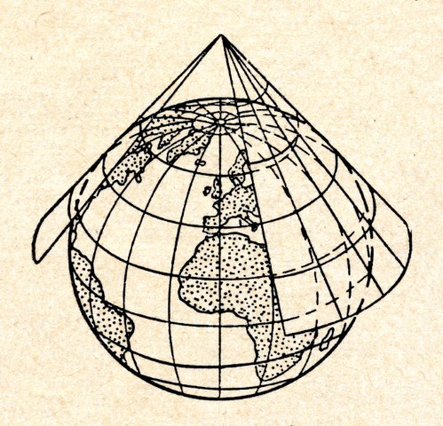
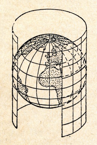
Distortion is an inherent consequence of map projection. Since the Earth's surface cannot be perfectly represented on a flat map, different types of distortions occur, and the choice of projection depends on the specific application.
Shape Distortion: Some map projections preserve the shape of features, meaning that lines on the map maintain their angles relative to each other. However, this comes at the expense of distorting area and/or distance.
Area Distortion: Other projections maintain accurate representation of areas, making it useful for calculating land areas or distribution. Nevertheless, this often leads to significant distortions in shape or distance.
Distance Distortion: Certain projections prioritize accurate distance measurements, which is crucial for navigation. However, this results in distortion of shapes and areas.
Direction Distortion: Some projections preserve accurate directions, making them valuable for navigational purposes. However, this often results in significant distortions in shape and area.
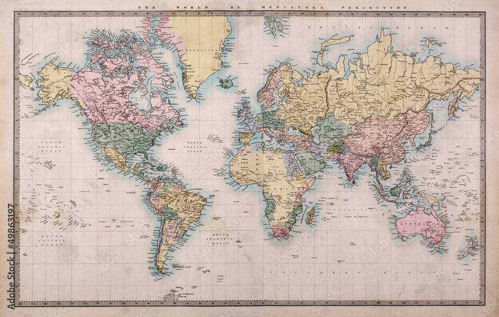
Standard Mercator Projected Map
Notice the size of Greenland compared to Australia.
Straight lines and angles are preserved, but the area is distorted
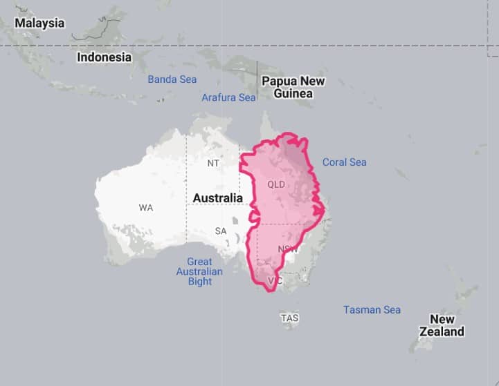
True Area of Greenland Compared to Australia
Courtesy of the True Size Map Comparison.
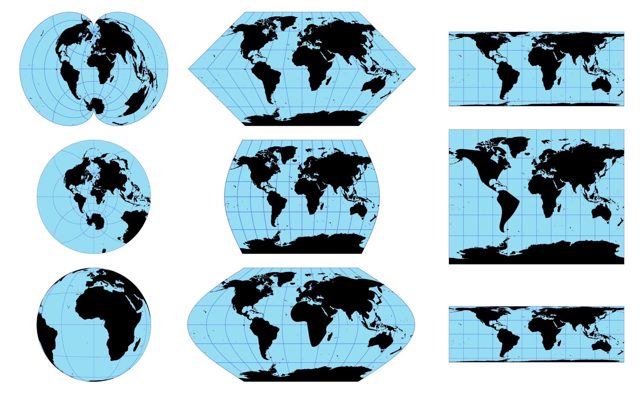
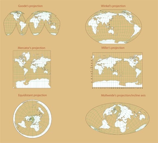
Common Map Projections
Several map projections are commonly used, and each one is tailored to specific applications:
Mercator Projection: Known for preserving angles and straight lines, the Mercator projection is widely used in marine navigation. However, it significantly distorts area, especially at higher latitudes.
Robinson Projection: This projection aims to balance area, shape, and distance distortions, making it suitable for general-purpose world maps.
Lambert Conformal Conic Projection: Frequently used for mapping large regions with an East-West orientation, such as the United States, this projection minimizes distortion along the standard parallels.
Albers Equal Area Conic Projection: Suitable for mapping regions with significant east-west and north-south extent, it preserves accurate areas while introducing some distortion in shapes.
Examples of Mapping Projections
The Role of Data Transformation and Georeferencing
Aerial images acquired from satellites or aerial platforms represent significant data collected from the Earth's surface. This data is often stored in various geographic coordinate systems, depending on the mission and the satellites used. Data transformation becomes crucial to align aerial images with a map projection accurately. This process involves converting the geographic coordinates of the image pixels to the corresponding projected coordinates on the flat map. A precise data transformation ensures that mapping lines and features on the aerial image align accurately with the chosen map projection.
The distortion resulting from map projections directly affects the mapping lines on aerial images. Depending on the projection used, some lines may appear curved or stretched, leading to apparent discrepancies in the relative positions of features. Distortion can be more pronounced in aerial images covering large areas or regions with significant latitudinal extent. As such, mapping lines on aerial images from polar regions may exhibit more noticeable distortions than those from equatorial regions.
Georeferencing becomes essential to mitigate distortions and ensure accuracy in aerial image mapping. Georeferencing aligns the aerial image to a reference system with known geographic coordinates. By referencing the aerial image to accurate ground control points, collected through surveying or GPS measurements, georeferencing corrects for distortions and ensures that mapping lines align correctly with the chosen map projection. Georeferenced aerial images are essential for accurate spatial analysis, decision-making, and seamless integration with other GIS data layers.
A Short Video Showing Map Projections
LAND SURVEYORS AND MAPPING
Mapping lines on aerial images may not always line up perfectly due to the challenges of representing a spherical Earth on a flat map. Distortions resulting from various map projections introduce complexities in accurately aligning features in aerial imagery. The trade-offs between preserving shape, area, distance, and direction in different map projections make it challenging to achieve a distortion-free representation.
However, data transformation and georeferencing play a pivotal role in ensuring accurate aerial image mapping. By referencing aerial images to known geographic coordinates and correcting for distortions, georeferencing ensures the alignment of mapping lines with the chosen map projection. By applying appropriate map projections, performing accurate data transformation, and relying on georeferencing techniques, land surveyors can confidently leverage aerial images for various applications, from urban planning and environmental monitoring to disaster response and scientific research.
I've attempted to explain and simplify a complicated subject. Professional land surveyors have extensive experience in applying data transformation and georeferencing in a variety of applications. There are many other professionals within the geospatial community that invest a significant amount of time learning and perfecting their knowledge of mapping. If you need additional assistance regarding mapping or have a project you would like assistance on, please fill out the form below.